Hi guys, I am reading in a geo tif, but when I use System.Drawing.Bitmap.GetPixel(bitmap,wi,hi) I get the pixels, but the values I get are all the same:
Color [A=255, R=255, G=255, B=255]
But why is System limiting me to the 0-255 step RGB values? I need the floating point values, can I get those?
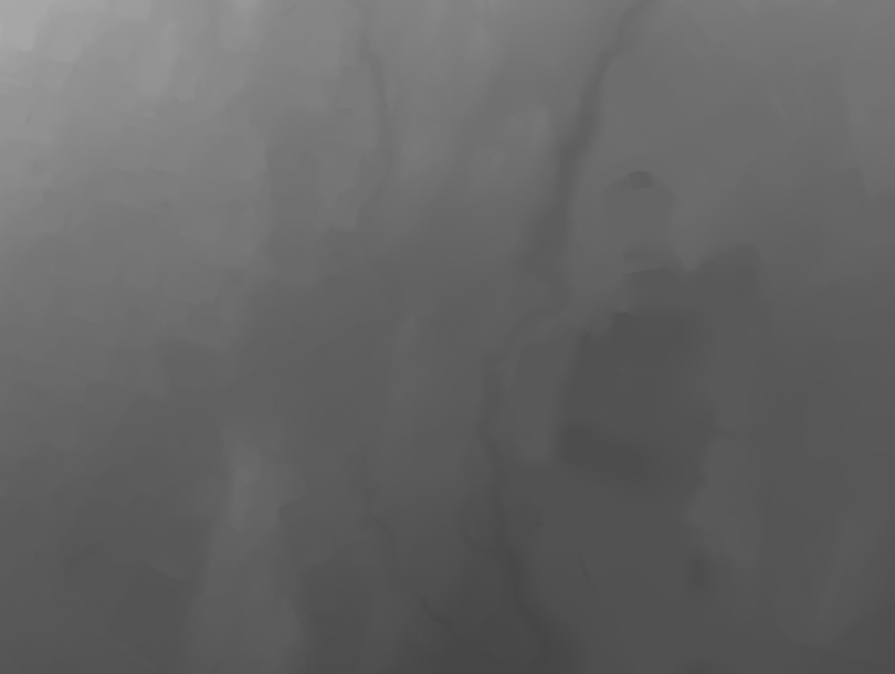
If I open the image in photoshop it appears all white, but stacking a few brightness and contrast filters reveal that the image has fine neuances:
on a mac:
affinity photo assigns a D50 profile on opening and your image looks like this…
preview will open the tiff all white.
Do you have any further info about the tiff file ? colordepth, created by…
Do you have the same problem if you read in a tiff with a gradient from white to black ?
Thanks for testing Tom, I don’t have any more info other than that it is in Format32bppArgb so I am confused why the values are returned as 0-255 values instead of 0.0-1.0
It seems awfully limiting to return the pixel as truncated… So I must do something wrong imo.
do you need to do it once ? is it your everyday workflow ? or is it a plug-in-development ?
if you just need to do the import once (and don t care about the complexity / performance of the workflow), you might find a geo-tiff to .csv converter and read in the text from the .csv.
sorry if i can t help further, but it looks like some special knowledge is needed about those geo-tiffs and reading them
I’ll have to type up a proper example later today (currently preparing lunch), but the approach would be:
<<read TIFF Bitmap>>
<<create render textuer using RenderTexture.NewBitmapTexture>>
<<get evaluator from texture>>
<<double loop over evaluator to get values>>
I am assuming here now that the render texture will maintain the bit depth of each TIFF channel.
@Holo I’m working on an example script, but I’m realizing that we have a problem with Rhino and 32bit TIFFs. Your TIFF has values way higher than 1.0f, but for instance Rhino itself loads the image like this:
at least on Rhino for Mac.
I’ll first have to figure out if Rhino currently properly supports TIFF as HDRi otherwise we can’t use RenderTexture and TextureEvaluator.
Yes, probably “just” a matter of ensuring we can create High Dynamic Range textures in Rhino with a TIFF, that way we can access values over 1.0 and belown 0.0. For instance EXR and HDR files can be loaded and evaluated with that. These type of textures work fine with Rhino Cycles using the evaluator.
What the… what does it mean to evaluate a “bitmap” with a 3dpoint… and with vectors? That passed sooo high above my head…
I get results, so stuff works, but I get the same value for all pixels, so obviously I am doing something wrong.
import Rhino
import scriptcontext as sc
import rhinoscriptsyntax as rs
import System

### Locate file
path=rs.OpenFileName("Selct image to trace", filter="TIF (*.tif)|*.tif| TIFF (*.tiff)|*.tiff| |")
#path=rs.OpenFileName("Selct image to trace", filter="PNG (*.png)|*.png| |")

### Load file and extract width and height
bitmap = System.Drawing.Bitmap.FromFile(path,False)
width = bitmap.Width
height = bitmap.Height

### print data
print bitmap.PixelFormat
print width,height

### Setup a RenderTexture and an Evaluator
RenderTexture = Rhino.Render.RenderTexture.NewBitmapTexture(bitmap,sc.doc.ActiveDoc)
Evaluator = RenderTexture.CreateEvaluator()

### I am adding vectors for the evaluator... have NO idea what they do so I point them in different directions just in case
v1 = rs.coerce3dvector((1,0,0))
v2 = rs.coerce3dvector((0,1,0))

### Make a list for points for the pointCloud
points = []

### Evaluate every pixel and add point to list
for x in range(width):
    for y in range(height):
        pt = rs.coerce3dpoint((x,y,0))
        color = Evaluator.GetColor(pt,v1,v2)
        px = (color.A+color.R+color.G+color.B)*1000
        points.append(rs.coerce3dpoint((x,y,px)))

### Add pointcloud and select it
cloud = rs.AddPointCloud(points)
rs.SelectObject(cloud)
There might be a “right way”… but that is not the fun way…
I am exploring the ability to skip some steps, and the process is really quite simple once the data can be read. (If/when it can be read )
I saved is as an EXR but I get an “Error: Out of memory”
path=rs.OpenFileName(“Selct image to trace”, filter=“EXR (.exr)|.exr| |”)
bitmap = System.Drawing.Bitmap.FromFile(path,False)
And if I load a JPEG then I also get the same values for every pixel.
import Rhino
import scriptcontext as sc
import rhinoscriptsyntax as rs
import System

### Locate file
#path=rs.OpenFileName("Selct image to trace", filter="TIF (*.tif)|*.tif| TIFF (*.tiff)|*.tiff| |")
#path=rs.OpenFileName("Selct image to trace", filter="EXR (*.exr)|*.exr| |")
#path=rs.OpenFileName("Selct image to trace", filter="PNG (*.png)|*.png| |")
path=rs.OpenFileName("Selct image to trace", filter="JPG (*.jpg)|*.jpg| JPEG (*.jpeg)|*.jpeg| |")

### Load file and extract width and height
bitmap = System.Drawing.Bitmap.FromFile(path,False)
width = bitmap.Width
height = bitmap.Height

### print data
print bitmap.PixelFormat
print width,height

### Setup a RenderTexture and an Evaluator
RenderTexture = Rhino.Render.RenderTexture.NewBitmapTexture(bitmap,sc.doc.ActiveDoc)
Evaluator = RenderTexture.CreateEvaluator()

### I am adding vectors for the evaluator... have NO idea what they do so I point them in different directions just in case
v1 = rs.coerce3dvector((0,0,0))
v2 = rs.coerce3dvector((0,0,0))

### Make a list for points for the pointCloud
points = []

### Evaluate every pixel and add point to list
for x in range(width):
    for y in range(height):
        pt = rs.coerce3dpoint((x,y,0))
        color = Evaluator.GetColor(pt,v1,v2)
        if x== 100 and y == 100:
            print color.A,color.R,color.G,color.B
        if x== 200 and y == 200:
            print color.A,color.R,color.G,color.B
        px = (color.A+color.R+color.G+color.B)
        points.append(rs.coerce3dpoint((x,y,px)))

### Add pointcloud and select it
cloud = rs.AddPointCloud(points)
rs.SelectObject(cloud)