First of all, thank you for this amazing plugin.
I noticed if I use the “Get REST Topography” component and set it to something other than the default “STRM GL1 (30m)” it works fine until I save and close the script. Upon reopening the script, the “Get REST Topography” component will still show the setting you change it to but it will actually reset to the default “STRM GL1 (30m)”. The image shows the top one as a reopened but not yet changed component showing the wrong URL and it returns the wrong geometry. The bottom one is one I’ve reset manually. There is nothing wrong with the components other than fetching the wrong database.
If I could make a side request, if you could replace the right-clicking and selecting with a value list or something similar to the “Create ESRI Raster Source List” would be much more intuitive to use, allows for parametric scripts to determine what should be picked, and it also allows integration with other plugins such a the HUMANUI interface.
Hi @nathanlundberg77 ,
Glad you like Heron! I think your idea that the interface to select the source data should be similar to the “Create ESRI Raster Source List” is a good one and will actually fix the other issue of the component remembering the correct source. I’ll get this into the next beta release.
-Brian
Hi Brian,
I’ve tried the v.0.4.3-beta.1 but I don’t think you were able to get this update into that push, I was hoping another update would’ve come along with the fix. I absolutely respect your time and effort on this plugin as I know it’s all volunteer work. I’m just trying to figure out a way around this bug as it’s holding up a UI interface I’m trying to make for my team. Do you think you’ll be able to get around to this fix anytime soon (no rush just trying to plan things out)?
Hi Nathan,
Apologies for the delay, I’ll see if I can get to it in the next couple of weekends.
-Brian
Hi Nathan,
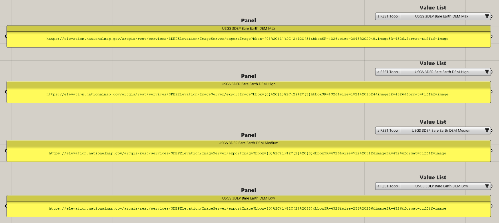
I just published Heron v0.4.3 (not a beta) which hopefully fixes the wrong URL bug you mentioned and adds an option in the menu to create a topo source dropdown like the one for raster sources. This dropdown can then be plugged into the new customURL input. The old Get REST Topography component was deprecated to allow this new functionality.
Take a look and let me know if it works.
-Brian
Hi Brian,
Thank you very much for the quick response and update. I was able to get that component working with no problem. For others reference:
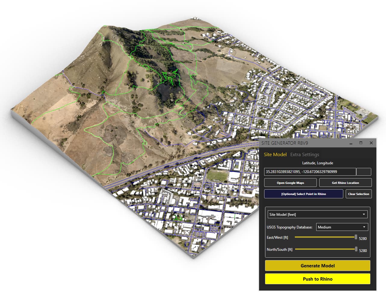
I figured it’s nice to see what others are doing with the plugin, here’s a screenshot of Heron + HumanUI I was able to setup for my team. I’m thrilled this works so well, thanks again Brian.
Hi Brian,
been working with heron for a while now and had a whole workflow for working with a topography going on. But it seems there`s an issue with the boundary input in the Get REST Topography.
the error is: Solution exception:Value cannot be null. (Parameter ‘path1’)
One week ago the script was working fine so I have no idea what it might be. The boundary however works with other components. Uploading script just in case..
heron_clean.gh (9.9 KB)
hi @paula_de_simone
I put up some workflow in your document. You need the Human plug-inn for colouring the terrain mesh.
heron_clean.gh (18.1 KB)
https://www.food4rhino.com/en/app/human
This is spectacular. Have you noticed any issues with vertical exaggeration when importing a .TIFF locally?
I do not think it has to do with tiff files importing locally. If you make a lib folder in the same directory as where your gh file is put then all should work normally. What you are seeing is maybe a document units issue. But I am not sure about this. The vertical scaling is not correct that is something for sure.
Hi Erik! thanks for the reply! Unfortunately the component is still not working for me (as the rest is) and getting the same error. Starting to think it might be something else, since it does work for you (ans used to work just fine a few days ago also for me) You know any possible workarounds to get a topography map that dont require this exact component?
Did you put a lib folder in the same directory as where your gh file is put?
yes I did. The other components as u can see in the screenshot are just fine - its the GET REST Topo the only acting oddly. Plus I get the error when connecting the curve.
Strange. Did you install Heron via the package manager?
just deinstalled-reinstalled it and nothing changed really
Did you try an other data source?